
Sometimes, a paddling trip is a dip into history.
On July 20, I set out to circumnavigate Thetis Island and ended up learning about shipwrecks, dredged channels and antiquated naming conventions from days gone by.
A Trail of Shipwrecks
From my launch spot at Blue Heron Community Park just north of Yellow Point in Cedar, I crossed Stuart Channel to Thetis Island via Miami Islet and the Ragged Islets. These islets are part of a chain of intertidal rocks and reefs that stretch north from Thetis Island. My chart showed two shipwreck symbols between Miami Islet and Thetis Island. Turns out this area was a popular place for ships to run aground in the early 20th century — likely until navigation markers were added to avoid more losses.
Tiny Miami Islet, just 200 metres long at low tide, is named after the ship it wrecked. The 320-foot coal ship Miami sank here in January 1900 after getting stuck on the intertidal islet on a high tide. Laden with 4,500 tons of coal for the Dunsmuir dynasty, the 3,000-ton Miami literally broke in half as the tide dropped and left the ship hanging on the rocks. The Miami‘s remains lie scattered north of the islet and south of the red nun buoy U40 that now marks safe passage around the area.

Another casualty to these islets was the Robert Kerr, a three-masted sailing barque turned coal barge. On March 4, 1911, the Robert Kerr hit the rocks and reefs while fully loaded under tow. It’s sunken remains lie between Miami Islet and the Ragged Islets, marked by a “Wk” symbol on marine charts. The Robert Kerr began its life in 1866 as a trade ship for the Hudson’s Bay Company. It was sold in 1885 to Hasting’s Mill in Vancouver, where it famously served as a floating refuge for hundreds of Vancouverites during the Great Vancouver Fire of 1886. In 1888, the Canadian Pacific Railway purchased the ship and converted to a coal barge, a role it filled for 23 years until it met its demise on the reefs north of Thetis Island.

As I paddled over the two wreck sites, I peered down into the water hoping to glimpse something recognizable, but all I saw were murky shapes, intertidal rocks and sunlight glinting off the water. I paddled on to Pilkey Point at the northeastern tip of Thetis Island, where this chain of notorious rocks and reefs originates, to begin my circumnavigation of the island.
Navigating “The Cut”
From Pilkey Point, I paddled clockwise down the east shore of Thetis Island until I arrived at Clam Bay and Canoe Pass — a.k.a “The Cut”. The Cut is a shallow intertidal channel that bisects the mudflats between Thetis Island and Penelakut Island to the south. The Cut is man-made, a canal of sorts that was dredged in 1905 to allow fishing vessels and other boats to more efficiently travel between Clam Bay and Trincomali Channel on the east side and Telegraph Harbour on the west side.
The Cut is rather infamous with local mariners: at just over 0.5 nautical miles long, it has twisty sections and shallow sections, is affected by tidal currents, and is capped at its eastern entrance by Rocket Shoal and Centre Reef. If you are at the helm of a keeled craft, navigating The Cut requires timing, skill, local knowledge and perhaps a healthy dose of luck!
Canoe Pass comes by its name honestly. Shallow-draft water craft like kayaks, rowboats and canoes can pass through The Cut most of the time, at much lower water levels. I arrived at the eastern entrance at a tide height of about 1 metre and was just able to paddle through without hitting bottom. I even had a push from the building flood tide to carry me along!


Cutting Ties with “Kuper” Island
On the south side of The Cut lies Penelakut Island, long-time home to members of the Penelakut First Nation. I was surprised to learn that Penelakut Island was until quite recently known as Kuper Island — so named after one Captain Augustus Kuper of the Royal Navy, who led a surveying crew in the area in 1851. (Incidentally, Thetis Island was named for Kuper’s 36-gun frigate, HMS Thetis, which was itself named for the sea nymph Thetis, a goddess of water in Greek mythology.)
Thankfully, Kuper Island was officially renamed Penelakut Island in 2010 to recognize the Penelakut First Nation who lived and continue to live there (though unfortunately the Island still bears its old colonial name on some charts and online resources).
In December 2023, BC Ferries changed the name of the vessel that serves Thetis and Penelakut Islands from MV Kuper to MV Pune’luxutth.
Circumnavigation Complete
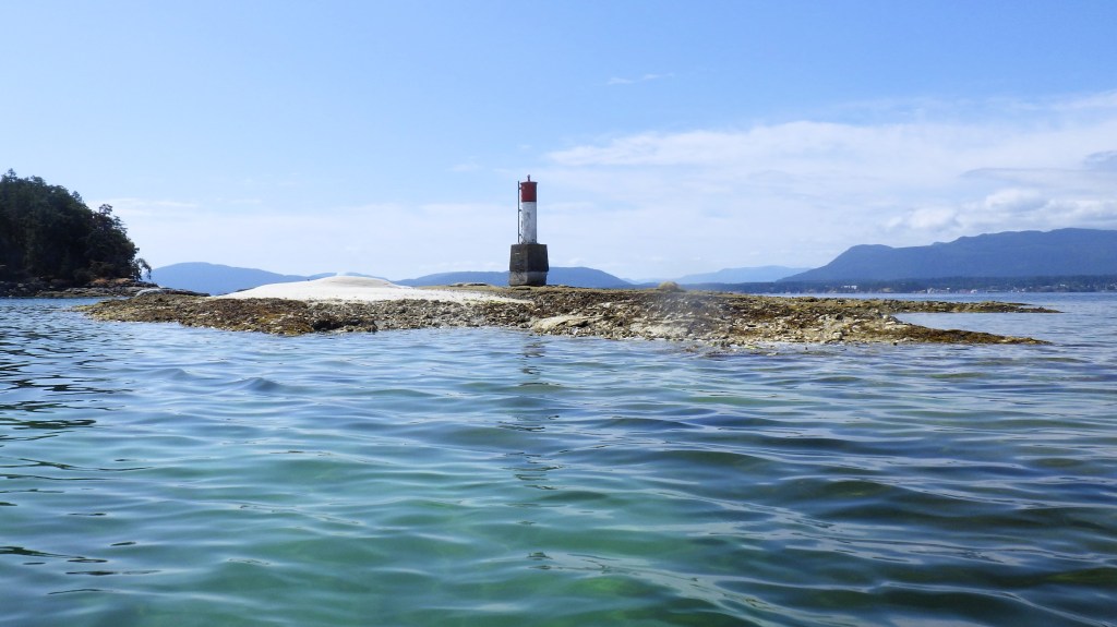
From The Cut, I paddled through Telegraph Harbour with its bustling marina and around Foster Point into Preedy Harbour, where BC Ferries vessels serve Thetis Island from Chemainus on Vancouver Island. I crossed over to the navigation light on the intertidal point north of Hudson Island, took a quick break on a sandy shore, then crossed to Dayman Island to connect with Crescent Point on the west shore of Thetis Island.
I had the flood tide at my back as I paddled north up the Thetis shoreline, alongside a train of north-moving pleasure craft in Stuart Channel. I arrived back at my starting point of Pilkey Point to complete my circumnavigation 2.75 hours after I started, covering a total distance of 9.4 nautical miles for the loop.
From here, I retraced my paddle strokes back to the Ragged Islets, Miami Islet and over to Blue Heron Community Park, navigating vessel traffic west across Stuart Channel with the wind at my back.
Total distance for the day was 15.9 nautical miles, with a paddling time of 4 hours 29 minutes and a total trip time of 4 hours 54 minutes.
It’s nice to go on a paddle that piques your interest in history and leaves you knowing an area just a little bit better for it.
